


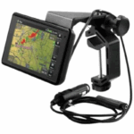
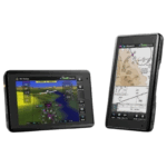
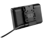
Garmin Aera 660 Touchscreen Aviation GPS Portable
Short Description
The Garmin Aera 660 is a rugged, compact aviation GPS navigator designed for cockpit use. It delivers full-featured glass‑cockpit-style navigation in a portable package, featuring a responsive 5‑inch sunlight-readable touchscreen, wireless connectivity, rich aviation mapping, and intuitive controls that mirror Garmin’s panel units and app interface.
Key Features
-
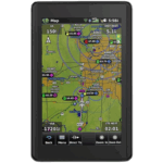
5″ Sunlight-Readable Touchscreen
Features a WVGA color TFT display (480 × 800 resolution), usable in both portrait and landscape orientations. -
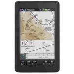
3D Vision & Synthetic Terrain
The revolutionary 3D Vision view shows terrain, obstacles, airports, and more in virtual 3D, complete with VNAV guidance and a 360° HSI. When connected to compatible avionics, the display is enhanced with SVX synthetic vision and pitch/roll indicators. -
Wireless Cockpit Connectivity (Connext®)
Stream ADS‑B weather and traffic wirelessly via compatible devices (GDL 52, FlightStream, GTX 345, etc.). Includes features like TargetTrend™, TerminalTraffic™, and animated NEXRAD. -
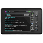
Smart Airspace & Obstacle Awareness
Smart Airspace™ highlights relevant airspace based on altitude. WireAware™ displays Hazardous Obstacle Transmission (HOT) lines for powerlines and features—touch to view MSL and AGL heights, with optional expanded powerline data. -
Preloaded Mapping & Flight Charts
Comes with US VFR Sectional and IFR enroute charts, SafeTaxi®, AOPA Airport Directory, optional Jeppesen ChartView™, and Canadian/EU VFR/IFR charts. Offers vertical profile views, parcel navigation, VNAV, and direct-to/nearest-airport features. -
Wireless Database Updates via Wi‑Fi
Update navigation databases—including U.S. fuel prices—without a computer thanks to built-in Wi‑Fi support. -
Panel Integration
With an optional power/data cable, it can accept flight plans from GTN 750/650, GNS 530W/430W, and send standby frequencies to NAV/COM radios such as GTR 200, GTR 225, or GNC 255.
Specifications & Technical Details
| Feature | Details |
|---|---|
| Dimensions | 5.5″ × 3.4″ × 0.8″ (14.1 × 8.7 × 2.1 cm) |
| Display Area | 4.35″ × 2.61″ (11.1 × 6.6 cm), 5.08″ diagonal |
| Resolution | 480 × 800 pixels, WVGA TFT with backlight |
| Weight | 245 g (8.64 oz) with battery; 205 g (7.23 oz) without |
| Battery | Removable rechargeable Li-ion; up to ~4 hours (day, 80% backlight + wireless), ~6 hours (night, low backlight, no wireless) |
| GPS Receiver | High-sensitivity SBAS/WAAS/GLONASS, built-in antenna; optional external antenna support |
| Connectivity | Wi‑Fi, Bluetooth, ANT+ |
| Memory | microSD™ card slot for data expansion |
| Power | 10–35 V input range |
| Traffic Info | Traffic Information Services (TIS) compatible |
Conclusion
The Garmin Aera 660 delivers advanced panel-grade navigation in a lightweight portable device. With features like 3D Vision, wireless ADS‑B weather/traffic, smart airspace awareness, Jeppesen chart support, and Wi‑Fi updates, it serves as a powerful electronic flight bag (EFB). Its intuitive touchscreen interface mirrors Garmin’s cockpit systems, making it both familiar and powerful for pilots.


Reviews
There are no reviews yet.